How Far Does a City Reach?
Under our Roads That Remember map, two commenters got into it about induced demand, the old argument about whether building roads creates traffic and development. One of them said something specific enough to test: a highway extends a city's reach only to about commuting distance. It can pull a far suburb into a metro's orbit, but it can't pull the middle of nowhere into anything, no matter how good the pavement is.
That's a measurable claim. We have every place at every interstate exit in the country, so we computed each exit's distance to the nearest metro area of a million or more people and lined them up.
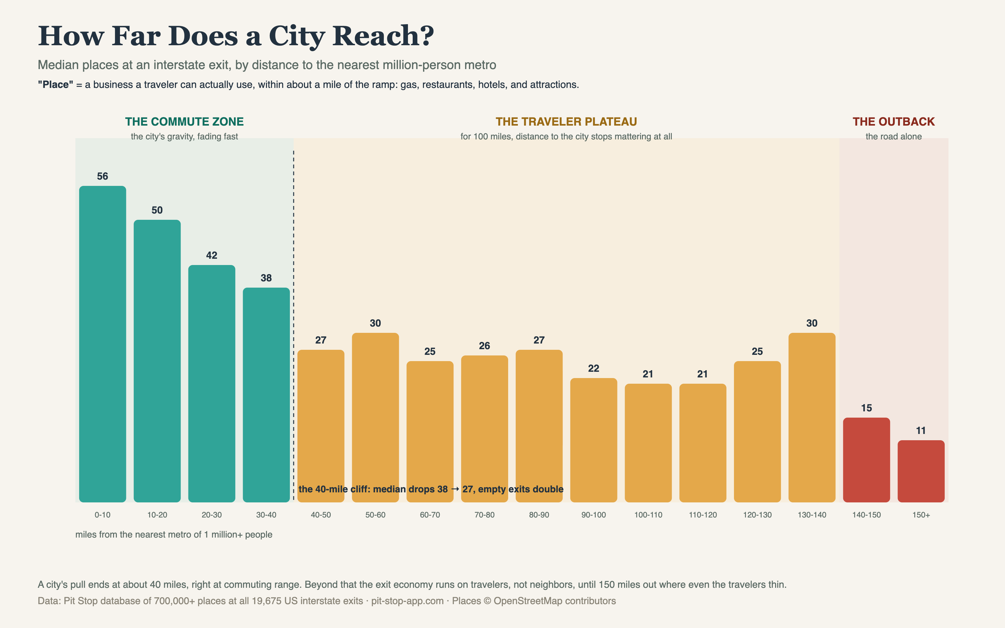
The commenter was right, and the number is sharper than we expected.
Three roads in one
The commute zone (0-40 miles). Inside 10 miles of a big metro, the median exit has 56 places and effectively zero exits are empty; 97% are packed. The city's gravity fades steadily out to 40 miles, which is right where a daily commute stops making sense. Everything the induced-demand argument is actually about, the subdivisions, the logistics parks, the exits that grow a Chick-fil-A the year after the lanes widen, lives in these four bars.
The traveler plateau (40-140 miles). This was the surprise. Past the cliff, the numbers go flat and stay flat for a hundred straight miles: median in the 20s the whole way, whether you're 50 miles from a metro or 130. Distance to the city stops mattering at all, because out here the exit economy isn't serving anyone who lives nearby. It's serving you, passing through. The road is its own economy: gas, beds, burgers, repeat. This is the land of the inheritance ladder, where what the road was built on decides which exits got stocked.
The outback (150+ miles). 2,507 exits sit more than 150 miles from any million-person metro. Median 11 places, 40% empty. Even the traveler economy thins when the travelers do. This is where our food deserts, fuel gaps, and best nothing exits all live.
So who wins the argument?
Honestly, both, in their own territory. The person who said roads reshape everything is right, inside 40 miles: that's where interstates and metros amplify each other into 56-place exits. The person who said a road through nowhere stays nowhere is right too: the plateau and the outback have had the same pavement for 70 years, and it never conjured a city, just a Loves and a Super 8 where the traffic makes it worth it. A road amplifies what's there. Inside commute range there's a city to amplify. Beyond it, there's just the drive.
Update: you asked for the map
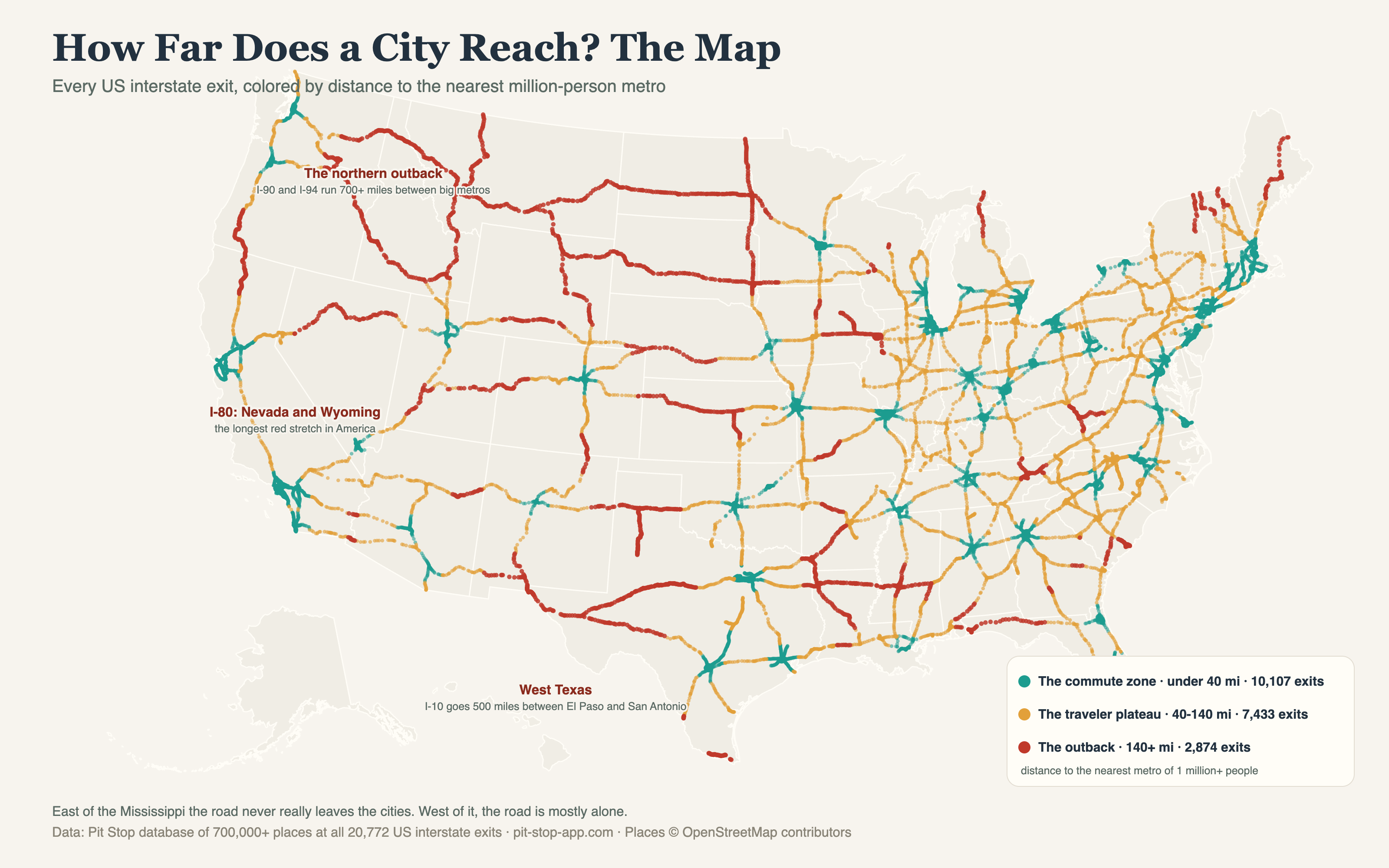
A reader asked what the three zones look like drawn on the country instead of a bar chart. Here it is: every interstate exit, colored by its zone. East of the Mississippi the road never really leaves the cities. West of it, the road is mostly alone — I-90 and I-94 run 700+ miles of outback across Montana and the Dakotas, I-80 crosses Nevada and Wyoming almost entirely in the red, and I-10 goes 500 miles between El Paso and San Antonio.
Update: the 500k version
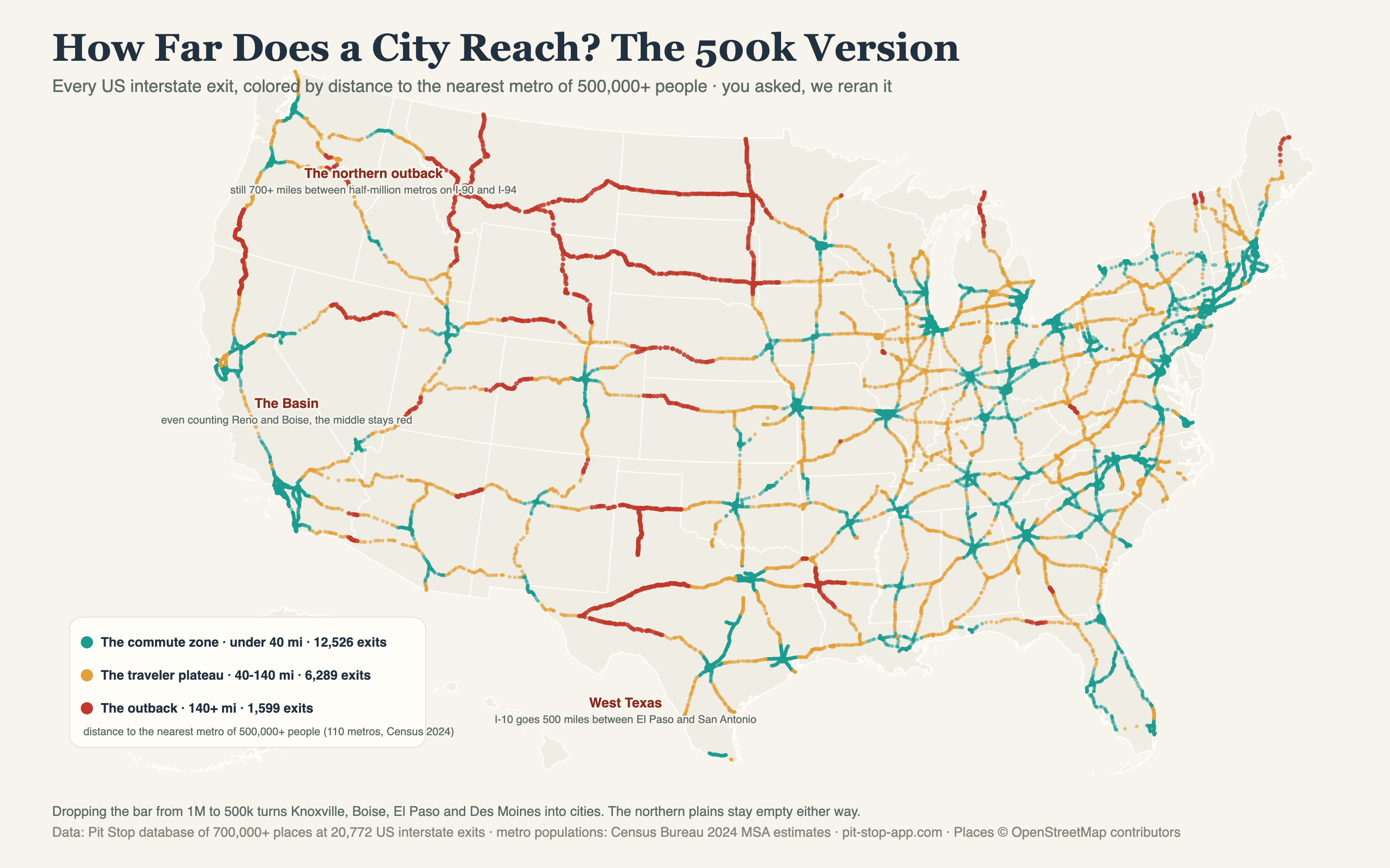
The map above drew a fair criticism: a million-person cutoff calls Knoxville, Boise, El Paso and Des Moines "the outback," which is silly if you live there. Commenters also caught two metros on our list that no longer clear a million (Albuquerque and New Orleans) and one glaring omission at the border: El Paso sits across the river from 1.5 million people in Juarez and our map called it remote.
So we reran it with the bar at 500,000, using the Census Bureau's 2024 metro estimates directly, all 110 metros over half a million. The commute zone grows from 10,107 exits to 12,526 and the outback shrinks from 2,874 to 1,599. But the shape of the country barely moves: the 40-mile cliff is still there, and the northern plains stay red either way. There is still no metro of even half a million between Spokane and Minneapolis.